
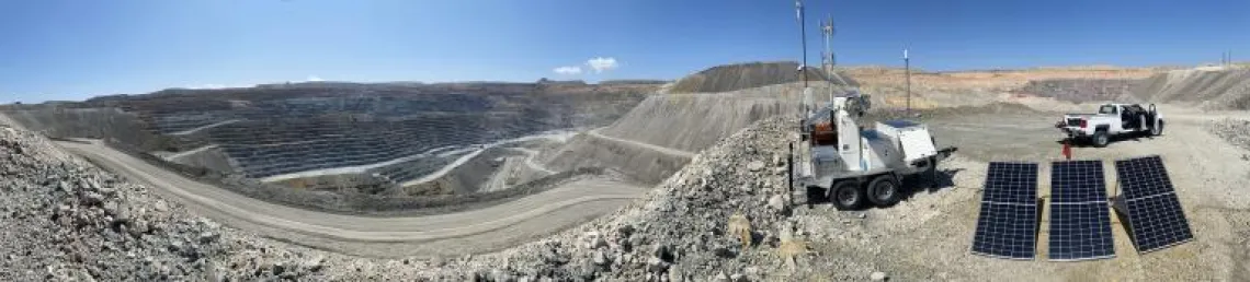
Mine site with IBIS-ArcSAR setup
Constant, rigorous monitoring of open pit mine slopes is critical to the safety of miners. Working under that premise, the Geotechnical Center of Excellence (GCE) at the Lowell Institute for Mineral Resources recently completed a comparison of two types of synthetic aperture radar (SAR) that can contribute to effective monitoring of mining sites.
The work by GCE’s Graduate Research Assistant Ryan Brock and Assistant Director Chad Williams has demonstrated that both satellite-based interferometric SAR (InSAR) and ground-based SAR provide different kinds of important information. When combined, they can provide a bigger picture of slope deformation that can be managed by an operation.
“The study is going to show that combining ground-based radar data with InSAR data can help mines focus their monitoring systems on the right hazards and also help limit the hazards that are missed,” said Brock, who is writing his master’s thesis and a paper on this project.
Results also will be used as a case study for mine engineering students and professionals. It will be part of the 2021 Geotechnical Radar Monitoring Course, a 15-week online and live professional development and academic discussion of the latest in slope monitoring technology.
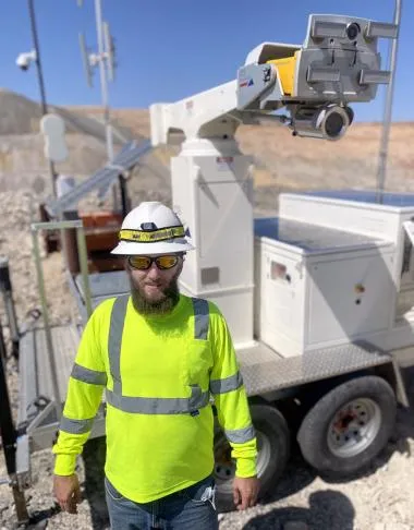
Ryan Brock with IBIS-ArcSAR
Brock deployed an IBIS-ArcSAR—a synthetic aperture radar which is mounted on a rotating arm—for two months of monitoring slopes at an active open mine pit and an inactive one. The equipment was on loan from IDS GeoRadar. Using processing software from IDS GeoRadar, Brock and Williams were able to track rapid deformation on the slopes in real time. Some of those movements were too fast to be tracked with InSAR.
Similar processing was done for data from an InSAR satellite passing over the same Arizona mine during the same time period. That data was furnished by 3vGeomatics. The data set revealed a large, very slow-moving zone of deformation that was not picked up by the initial real-time processing of IBIS-ArcSAR data.
Each technology has its strengths
One reason for the different results has to do with the frequency of the scans. IBIS-ArcSAR equipment can scan in short intervals and the team initially took scans every two to three minutes. The InSAR scans were taken every 12 days, an interval that did catch the zone of deformation.
The researchers adjusted the time interval of scanning with the IBIS-ArcSAR, which allowed for more measurable deformation to occur between scans. This technique, called radar subsampling, allowed the researchers to track very slow-moving hazards. These were identified by InSAR and thus the two results were more closely matched.
Other differences in the results stemmed from the two instruments’ line of sight to the slopes. The IBIS-ArcSAR can detect deformations moving toward and away from its antenna. InSAR could cover a large area, and its aerial view can detect movement up and down, as well as east and west. Real-time monitoring by ground-based radars can improve miner safety by setting off alarms if a failure is imminent. InSAR provides a big picture of slope stability issues that need addressing and possibly require further monitoring.
Neither of these technologies is new, but applying them to mining, particularly slope monitoring, is gaining in use. “This type of satellite SAR is becoming more and more affordable,” Brock explained.
Williams said many mining companies have adopted InSAR monitoring over the last five years, and all are slowly building their own sets of case studies. This study aimed to produce a use case for all engineers to review. The two monitoring methods are rarely rigorously compared. This is what spurred the project. “The research objective is finding new ways to integrate data,” Williams said. “This work simply shows how these two technologies complement each other.”