
UArizona gives impulses for R&D consortium
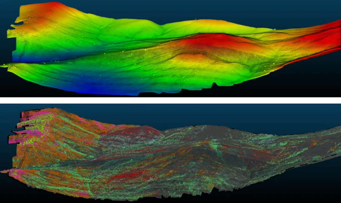
Carson Roberts, Headwall PhotonicsTop: LiDAR elevation map of the Cuprite Hills, NV. Bottom: Spectral mineralogy of the Cuprite Hills, superimposed on LiDAR.
Mines today don’t have much margin for error: low grades and complex mineralogy increasingly make for challenging economics. Sometimes, those problems just can’t be solved. Geologists and engineers have to work with ore deposits as they are.
But at least they might be getting some new tools to help. Hyperspectral imaging, a spectroscopic technique that allows humans/sensors to “see” infrared light, extends the range of minerals that can be detected in the field, including some important additions. Take clays for example. There are whole books about how clays can mess with mining operations (https://doi.org/10.1017/9781316661888), but they’re some of the hardest minerals to detect (let alone distinguish from each other) in the field by traditional methods. That’s in the visible-light range. In hyperspectral imaging, though, clays are easy to pick up and to distinguish into different clay species.
Hyperspectral imaging has been around for years in agriculture, forestry, and other industries , but it’s just starting to be picked up in mining. Mine environments are far more complicated than other places where hyperspectral imaging is usually applied. There are more species that show up in infrared scans, many of which look very similar, occurring at ultrafine grain sizes over a large mine area. That requires a combination of spectral resolution, spatial resolution, geographic precision, rapid data turnaround, and mineralogical finesse that’s not readily available from existing hyperspectral imaging systems.
Academia and industry band together
A new UArizona initiative plans to change that. On October 8th the University hosted 30+ engineers, geologists, metallurgists, and other mining professionals from industry, academic, and government sectors for an R&D mini-symposium on adapting hyperspectral imaging technology for mine site applications. In attendance were representatives from mining, surveying, mine software, sensor, and technology companies, and University faculty and students from various branches of engineering.
It started with a summary of research to date: what can we see when we use our hyperspectral eyes to look at mine highwalls? Heap leach pads? Tailings facilities? Undeveloped exploration sites?
Isabel Barton and Jingping He from the Mining and Geological Engineering Department and Leon DuPlessis presented results from pilot studies of hyperspectral imaging on highwalls and leach pads.
David Brady and Ron Driggers, College of Optical Sciences talked about their current research in new field sensor technology and real-time target identification using spectral imaging (including live infrared tracking of large snakes hidden in tall grass).
Carson Roberts, Senior Applications Engineer at Headwall Photonics, Inc. showed hot-off-the-press results from a drone-based scan of the Cuprite Hills, Nevada (cf. images above)
This input fueled the discussion among participants, which revolved around two questions: How can hyperspectral imaging systems be optimized for the mining environment? And how can the University help? Kamel Didan brought interdisciplinarity to live with contributions from the perspective of Electrical and Computer as well as Agricultural-Biosystems Engineering.
All participants supported the idea of joining forces in an R&D consortium and the conversations are continuing this fall/winter. Stay tuned for further developments!
For more information on the consortium and access to symposium slides, please contact: Isabel Barton(link sends e-mail)
UArizona researchers at the mini-symposium
Isabel Barton [link to profile] - David Brady [link to profile] - Kamel Didan [link to profile] - Ron Driggers [link to profile]